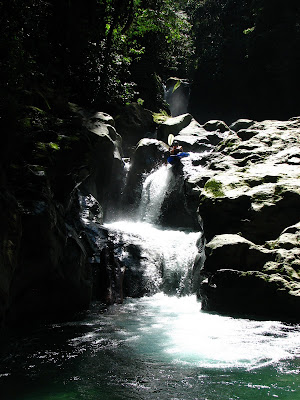
 The Rio Zacate flowing out of Pico Bonito national park. This whole mountain range has largely intact rainforest and rises up just a few miles from the Gulf of Mexico.
 Did I first d the Rio Cuyamel? Only it knows.
 Udo shows me down the upper Congrejal, a cherry-creek style run, at a great level. Udo goes way back in Honduras, all the way to '92 when he went on a badass kayaking trip on which he and his boys found a totally runnable river with a clean 30 footer and a bar at take out (Hopefully I'll make it back for that one). He decided Honduras was the place and has run a raft company on the Congrejal ever since.
Honduras- As big as you want to go...
Honduras marked the turn-around point of the road trip. Kat and I motivated down through Guatemala to go Scuba diving at an island off the Honduran coast which we had heard was the cheapest place in the world to blow bubbles amongst the coral. It was a crazy place, most of it was at most a foot above sea level and swampy and though there were hardly any cars on the island the locals constantly tore around on 4-wheelers and mopeds, providing a droning back-drop. When we were ready to leave, a 4-day storm system moved in, preventing the ferry that had taken us to the island from making its trips. So we stayed a while. When we made it back to the mainland, some of the rain was still draining out of the mountains, as you can see above. This part of Honduras really made an impression on me with its natural beauty and the extent to which it has been left pristine as compared to other places we saw on the road trip. I really just scratched the surface here and I think it is the most under-rated kayaking destination in Central America.


1 comment:
How far to these rivers from San Pedro Sula? I travel to San Pedro fairly frequently for work, and have always wondered what's up in the mountains that's boatable. But finding shuttle partners there seemed to be a daunting proposition.
Jerry
Post a Comment